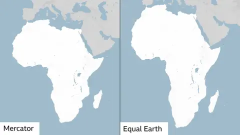
The UN General Assembly has approved an African-led resolution promoting world maps that accurately represent the relative sizes of continents, challenging the widespread use of a projection that visually diminishes Africa.
The “Correct the Map” resolution, sponsored by Togo and supported by African Union members, secured 164 votes, including those of Britain and France. The United States cast the only opposing vote, while six countries abstained.
Although non-binding, the resolution seeks to encourage institutions worldwide to adopt maps that better reflect the proportions of the Earth’s land masses.
At the centre of the campaign is the Mercator projection, which makes Greenland appear roughly comparable in size to Africa, despite the continent being about 14 times larger.
Developed in 1569 by Flemish cartographer Gerardus Mercator for maritime navigation, the projection increasingly exaggerates areas farther from the equator. This enlarges the appearance of northern regions relative to much of Africa.
All flat maps involve compromises when translating the Earth’s curved surface into two dimensions. However, different projections preserve different properties, such as angles or relative area.
Campaigners favour the Equal Earth projection, developed by a team of cartographers in 2018 to preserve the relative areas of countries and continents. The African Union’s 54 member states adopted it in February.
Supporters argue that the issue extends beyond geography, saying familiar maps influence perceptions of Africa’s economic importance, resources and place in global affairs.
Ahead of Friday’s vote, Togolese Foreign Minister Robert Dussey told Reuters: “A fair world begins with a fair map.”
Dussey has argued that maps shape how people understand the position of nations and continents, making their design a matter of international significance.
France supported the initiative, with Foreign Minister Jean-Noël Barrot announcing that his ministry would stop using the Mercator projection. He said correcting distorted representations was worthwhile even if changing maps could not, by itself, change global realities.
Washington rejected that argument. US representative Yaryna Ferencevych criticised the debate as a distraction from the General Assembly’s responsibilities concerning peace, prosperity and relations between nations. She also objected to the initiative’s links to reparations and cognitive justice.
Campaign organisers say Africa’s portrayal on maps contributes to a broader pattern of misrepresentation.
Lerato Mogoatlhe of Africa No Filter, one of the organisations behind the initiative, told the BBC that the campaign aimed to challenge entrenched narratives about the continent.
Kenyan geographer Kioko Muendo similarly argued that maps influence political and economic perceptions, with Mercator’s distortions helping obscure the scale of Africa’s resources, population and investment opportunities.