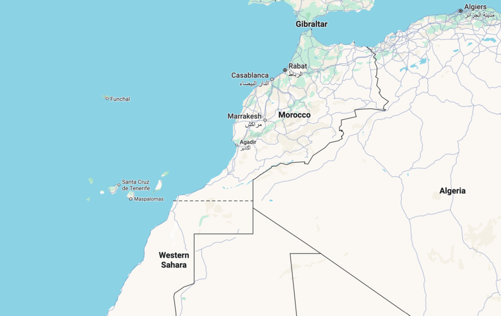
A dotted line marking the border between Morocco and Western Sahara vanished from Google Maps for Moroccan users on Saturday, hours after a United Nations vote backed Rabat’s autonomy plan for the disputed territory.
The UN Security Council on Friday endorsed Morocco’s 2007 proposal granting Western Sahara autonomy under Moroccan sovereignty, a move opposed by the Algeria-backed Polisario Front, which demands full independence.
The disappearance of the border line was first observed by AFP, which noted that the demarcation remained visible to users outside Morocco, including in Algeria, the United States, and France.
On social media platforms such as X and Facebook, Moroccan users celebrated the change. “The imaginary line is no more,” one user wrote, echoing widespread nationalist sentiment.
Western Sahara, a vast desert region rich in phosphates and fisheries, was annexed by Morocco after Spain’s withdrawal in 1975. The territory has since been at the heart of one of Africa’s longest-running conflicts, pitting Rabat against the Polisario Front, which seeks independence through a UN-promised referendum that has yet to materialise.
The Security Council has long urged Morocco, the Polisario Front, Algeria, and Mauritania to return to negotiations for a lasting settlement. Yet Friday’s resolution marked a shift in tone, reinforcing support for Rabat’s autonomy initiative, first bolstered by the United States under President Donald Trump in 2020.
For many in Morocco, the vanishing line symbolises diplomatic progress. For others, it highlights how technology can mirror — or magnify — the world’s geopolitical divides.