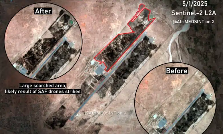
New satellite imagery has revealed extensive fires and destruction inside Nyala airport, highlighting the scale of damage inflicted on the strategic facility in South Darfur amid Sudan’s ongoing war.
Analysis of the images shows that burned areas inside the airport complex cover an estimated 800,000 square metres, pointing to a large scale and deliberate strike on the site, which has been under the control of the Rapid Support Forces.
The imagery indicates that the fires were concentrated in sensitive locations near the runway and the main aircraft parking apron, suggesting severe disruption to the airport’s operational and logistical infrastructure.
According to assessments cited by media reports, the damage is believed to have resulted from targeted drone attacks carried out by SAF on 2 January. The strikes appear to form part of a broader campaign aimed at severing supply routes and degrading the logistical capabilities of its rivals, regardless of the wider civilian and humanitarian consequences.
The satellite evidence contradicts claims circulated by the Port Sudan authorities regarding the nature and impact of the attack, and has fuelled renewed debate over SAF’s expanding use of drones against infrastructure in conflict zones.
Analysts say the scale and precision of the strikes raise serious questions about the military’s conduct, particularly as Nyala airport has long been a critical hub in a densely populated urban area already devastated by months of fighting.
No independent investigation has yet been announced, and SAF has not issued a detailed response to the findings highlighted by the satellite imagery.